


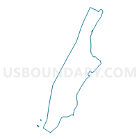
Voting District 7100100, New York County, New York
About
Outline

Summary
| Unique Area Identifier | 632286 |
| Name | Voting District 7100100 |
| County | New York County |
| State | New York |
| Area (square miles) | 0.01 |
| Land Area (square miles) | 0.00 |
| Water Area (square miles) | 0.01 |
| % of Land Area | 0.00 |
| % of Water Area | 100.00 |
| Latitude of the Internal Point | 40.84380000 |
| Longtitude of the Internal Point | -73.92953180 |
Maps

Graphs
Select a template below for downloading or customizing gragh for Voting District 7100100, New York County, New York


Neighbors
Neighoring Voting District (by Name) Neighboring Voting District on the Map
- Voting District 7100060, New York County, NY
- Voting District 7100092, New York County, NY
- Voting District 7100102, New York County, NY
- Voting District 7100103, New York County, NY
- Voting District 7700013, Bronx County, NY
- Voting District 7700014 7700015 7700018-7700020 7700081, Bronx County, NY
Top 10 Neighboring County Subdivision (by Population) Neighboring County Subdivision on the Map
Top 10 Neighboring Place (by Population) Neighboring Place on the Map
Top 10 Neighboring Unified School District (by Population) Neighboring Unified School District on the Map
Top 10 Neighboring State Legislative District Lower Chamber (by Population) Neighboring State Legislative District Lower Chamber on the Map
Top 10 Neighboring State Legislative District Upper Chamber (by Population) Neighboring State Legislative District Upper Chamber on the Map
- State Senate District 28, NY (321,361)
- State Senate District 30, NY (318,569)
- State Senate District 31, NY (292,157)
Top 10 Neighboring 111th Congressional District (by Population) Neighboring 111th Congressional District on the Map
Top 10 Neighboring Census Tract (by Population) Neighboring Census Tract on the Map
- Census Tract 205.01, Bronx County, NY (6,996)
- Census Tract 201, Bronx County, NY (4,013)
- Census Tract 311, New York County, NY (2)